
Extracting value from the nation’s vast digital property estate
Infrastructure View talks to the Land Registry about digitising property data and making it more accessible.
Tailored newsletters for you
Sign up to our newsletter to receive further information and news tailored to you.
When it comes to property data, HM Land Registry (HMLR) certainly has plenty. Infrastructure View spoke to Lynne Nicholson, Head of Data and Lead Product Manager at HMLR, about the ongoing work to digitise this data and make it more accessible.
It is something of a mind-boggling fact that there are around 28 million individual land titles in England and Wales, each setting out the ownership, tenure, easements and covenants relating to all the residential and commercial properties across the nation.
Perhaps even more staggering is the reality that this vast property estate translates into literally billions of individual paper documents, which detail information such as maps and plans, titles and restrictive covenants. While these documents are all now stored digitally, the originals are also kept and available for inspection in a vast, secure, highly fire and flood proof government warehouse.
Managing this huge set of records is the responsibility of HM Land Registry (HMLR), a non-ministerial government department, created in 1862. Times and technology have, of course, changed quite a bit since it was first established. Today these records are stored within the biggest property database in Europe and provided electronically, usually as the scanned PDF that will be familiar to anyone who has purchased a property or carried out a land registry search recently.
But, with the acceleration of data management tools and the drive by government to open and create value from its data, HMLR is now busy taking the next step towards maximising the usability of its data through greater use of application programming interfaces, Unique Property Reference Numbers and machine readability. This means moving away from a register of raster images - essentially pictures of paper documents which are accessible online but are not particularly interoperable.
As Lynne Nicholson, HMLR’s Head of Data, puts it, the “new strategy builds upon the strong foundations established under our previous one. However, rather than continuing to focus on the sharing of additional datasets from the register, we will focus on increasing the usefulness of the data that we already make available.
“Over the next 3 years, we want to expand the opportunities for using our data in new ways. Alongside this, we aim to increase the quality of our data so it’s more valuable to a larger number of users. We hold a critical national asset and are responsible for allowing the nation to access and use it as effectively as possible.
“At the moment, most of our statutory products are provided as PDFs, which makes them very hard to deal with – this will all change in the not-too-distant future.”
Making data useful
Nicholson is the Senior Responsible Owner (SRO) for many of HMLR’s ambitious data projects which are designed to transform the way HMLR manages, updates and shares its vast amount of data.
The driving force is the government's initiative to use data to drive the economy. Whereas 20 years ago government departments were encouraged to create commercial, revenue-generating services, today the emphasis is to make data available to enable the private sector to invest, innovate and drive national economic growth.
This saw, for example, HMLR join forces with Ordnance Survey to create the hugely successful Geovation Accelerator Programme to encourage start-up companies to examine and play with data and build businesses based on it.
HMLR’s data projects include a series of specific projects. One is to restructure the textual data to make it machine readable; another will revamp the spatial data; a third will build a new cloud-based platform that will provide the capability to analyse and share the data more effectively; and a fourth looks at how best to publish the data and make it more accessible for people and businesses to use and improve.
“We are trying to structure the data and our services in a different way so that we can do all sorts of 21st century things with it,” Nicholson explains. “At the moment, we are working through the first stages of these projects, doing all the investigative and foundational work to ensure we meet the strategic aims of HMLR and become the best in the world in terms of sharing the data that drives economic growth.”
Digital Street pilot
The data projects dovetail with the so-called Q-FAIR initiative being spearheaded by the Geospatial Commission, which is trying to ensure that public data is Findable, Accessible, Interoperable, Reusable and of the right Quality - fit for purpose.
“We fully support that initiative,” says Nicholson, who is on the Geospatial Commission’s Strategy Team and Working Party. “We need to make our data far more findable and accessible – and clearly a PDF is certainly not interoperable. For us to support the Geospatial Commission strategy, we need to invest in the basics, the foundations, and the necessary capabilities.”
HMLR has already tested the water in terms of embracing this new world of accessible data, having completed a pilot research and development project called Digital Street. This created a virtual street and was designed to see if the HMLR’s data could be pulled together and made more accessible and interoperable.
It was successful but was parked while the concept for the wider data transformation ambitions were assessed and agreed. Fundamentally, the Digital Street project showed what was possible and identified, perhaps more importantly, where value could be created.
Snow Hill demonstrator
In fact, two years ago, Carter Jonas ran a similar pilot project to digitize information relating to property around the proposed Snow Hill Station development for Birmingham City Council.
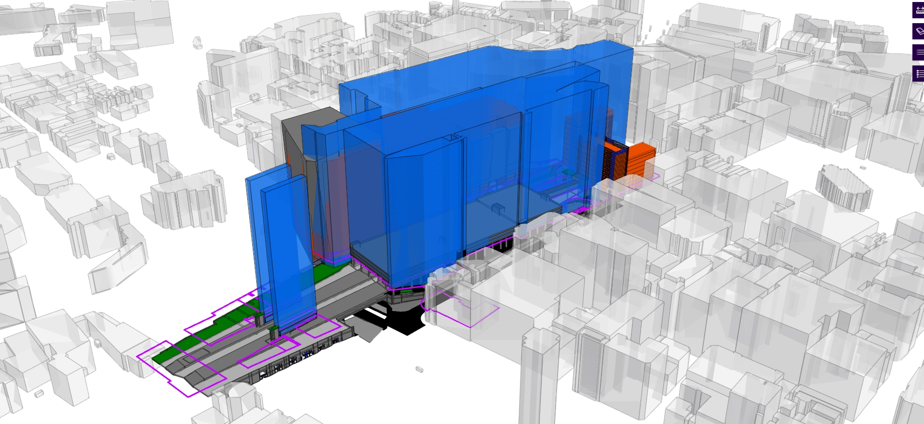
Digital Twin
Fig. 1: Carter Jonas’ 3D land referencing model of Snow Hill Station, Birmingham
This project created a fully-fledged 3D digital model of the commercial buildings and attached available HMLR information such as ownership, tenure and air rights, to create a searchable and visual representation of the area, for potential developers to access and to try to better understand the impact of the development.
At the time, there was no real requirement for a live model. This meant any changes to the data had to be monitored and then manually adjusted to ensure that the model stayed true to reality.
Without investment to make this happen, the model was simply a snapshot in time rather than a useful on-going tool.
The digital data future has already started
HMLR’s data projects are ploughing ahead making useful property data available, particularly for commercial property which is not limited by such stringent data protection regulations preventing the bulk release of private individuals’ data.
Already it is possible to visit the HMLR online portal and download property information from 13 different datasets, 10 of which are free under the so-called Open Government Licence agreement.
This means that data consumers can create a digital map of England and Wales onto which they can download HMLR’s spatial data. And since this data has title numbers embedded, it is then possible to download and attach any of the other datasets to create a searchable and useful database.
“Visually this looks fantastic, enabling users to zoom in, see the title number of properties, see if it is freehold or, if leasehold, what the term of the lease is,” explains Nicholson. “You can see who owns the property, whether it’s an overseas company or a UK company and how much they paid for it. And, depending on use and need, other information can be overlaid onto these datasets as commercially required.”
Making data live and useful
However, just like the Carter Jonas Snow Hill model, she points out that this data is still limited as it is not live, instead relying on the user to update new data by downloading new CVS files each month. While there is a service available to only update changes each month, it is a cumbersome process and not particularly user friendly or interoperable.
Nicholson points out that to meet the goals of Q-FAIR, this has to change. Hence the focus of the data projects is to build the infrastructure capable of accelerating the move towards a truly live model environment.
“We need to be able to create more useful offerings,” she says, pointing out that, for a project of this scale, change will inevitably have to evolve in stages.
“For example, a lot of organisations have asked for on-demand access to the data so they can get the right amount of data at the right time, rather than having to download the whole dataset for England and Wales every single month,” she explains. “We need to have the necessary infrastructure and database architecture at our disposal to enable that service transformation.”
Currently, the data is stored in a digital enterprise warehouse which, says Nicholson, is “not really the way to go in the 21st century.” Moving data into the cloud is the key to making it more accessible and developing the right environment needed to offer a much better service. The new platform will mean that, in around 18 months’ time, HMLR can start to look seriously at offering a range of new interoperable services that will eventually transform the way the market can use and exploit its data.
“We want to get to a stage where people can quickly build up a picture of a specific area, rather than trawling through a variety of England and Wales datasets and filtering them,” she explains. “This is such a new area for us; there is a lot of new technology and a lot of new capability. We know how big a task this is, so we're going to take it slice by slice. Exciting times.”
Research and Insights
 Read insight
Life Science Market Report | Spring 2026
Welcome to Carter Jonas’ Life Science Market Report Spring 2026, our biannual update on the outlook for the life sciences sector across the UK, focusing on the key markets of Oxford, Cambridge and London.
 Read insight
Central London Net Effective Rents Monitor Q1 2026
Our Q1 2026 Central London Net Effective Rents Monitor illustrates the combined impact of changes to both prime headline rents and the typical length of rent free periods across 22 central London districts.
 Read insight
Investment Quarterly Q1 2026
Our research specialists, working with our national and regional investment professionals, have released the latest Carter Jonas UK Investment Quarterly report for Q1 2026.
Tailored newsletters for you
Sign up to our newsletter to receive further information and news tailored to you.