


East Witney Strategic Development Area, OX28
Approximately 38.88 acres (15.73 hectares), pending determination of an appeal relating to an outline planning application for 450 dwellings and infrastructure. For sale as a whole.
LOCATION
The East Witney Development Area is located on the south eastern flank of Witney in West Oxfordshire.
Witney is a historic market town situated within the Windrush Valley, 12 miles west of Oxford and 8 miles east of Burford. It is the largest market town in the Oxfordshire Cotswolds with a population of 27,000 people. The town provides a range of facilities, which also serve a number of surrounding villages. It currently has eight primary schools, three county secondary schools (Henry Box School, Wood Green School and Springfield School) and an independent school (The King’s School). In addition, the town has several supermarkets, health and leisure provision, civic buildings and a number of national and independent retailers and restaurants.
Communications are excellent with the nearby A40 providing easy access into Oxford and Cheltenham (29 miles west). The nearby train station at Long Hanborough (5 miles north east) provides regular and direct services to Oxford Central in 9 minutes and London Paddington in 1 hour 7 minutes. Alternatively, Oxford Parkway train station (10 miles east) offers a direct service to London Marylebone in 56 minutes. In addition, buses depart every 20 minutes from the Market Square, linking neighbouring villages and Oxford city centre. The Oxford Tube bus service also operates from Witney providing services to Marble Arch and Victora 7 days a week.
PROPERTY
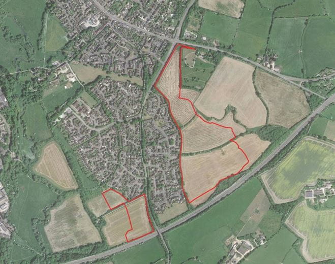
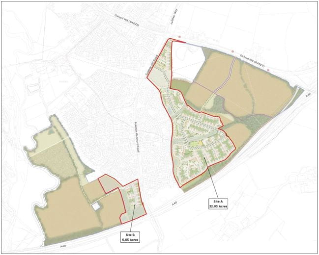
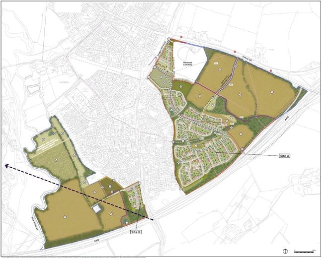
The property comprises two principal parcels of land, known as Cogges Triangle (32.03 acres) and Cogges South (6.85 acres).
SITE A – ‘COGGES TRIANGLE’
Cogges Triangle extends to approximately 32.03 acres (12.96 hectares) and comprises three main parcels of arable farmland, separated by existing field boundaries that are formed by native hedgerows and field margins. The land rises gradually to the north from the A40, from an levation of approximately 87m AOD in the south to around approximately 113m AOD along the northern boundary at Oxford Hill, with a south-west facing aspect.
The northern boundary of Cogges Triangle is largely formed by Oxford Hill (B4022) and skirts around the boundary of the Windrush Cemetery. The eastern boundary is formed in part by existing field boundaries and the Windrush Cemetery. The southern boundary is formed by the A40 with a belt of mature trees and hedgerows that restrict views into the property from passing vehicles. The western boundary sits adjacent to existing housing on Blakes Avenue, Eton Close and also Cogges Hill Road itself up to the point that it joins Oxford Hill (B4022). To the west lies the remainder of the Cogges Estate with a multitude of pedestrian and cycle routes, enabling convenient access to the town centre and other local amenities.
SITE B – ‘COGGES SOUTH’
Cogges South, the smaller of the two parcels of land, extends to approximately 6.85 acres (2.77 hectares) and is also in agricultural use as arable farmland.
The land is broadly level and is situated between an area of existing housing on Manor Road to the north, and the A40 to the south. The eastern boundary of the site is formed by Stanton Harcourt Road, while the western boundary is formed by a thick mature hedgerow interspersed with a number of mature trees.
PLANNING
The East Witney Development Area is allocated in the West Oxfordshire Local Plan 2031 where the provision “of about 450 homes” is envisaged. The Development Area will accommodate a sustainable and integrated community and will be a positive addition to Witney that will rovide for a balanced and appropriate mix of residential accommodation.
An outline planning application was submitted on 2nd September 2020 under reference 20/02654/OUT to West Oxfordshire District Council for: “Outline planning application (with all matters reserved except access) for the erection of up to 450 dwellings together with associated open space and green infrastructure (Amended)”. The application was refused on 31st May 2023. Our clients lodged an appeal against this decision on 23rd November 2023 (PINS reference - APP/D3125/W/23/3333790). The inquiry will now take place on 18th-27th June, with a target decision date by the end of July.
TECHNICAL UPDATE
Oxfordshire County Council has proposals to add eastbound off-slip and westbound onslip roads at the A40/B4022 Shores Green junction to improve access to Witney.
This work will be funded by a combination of Housing and Growth Deal (HGD) fund and Section 106 contributions. The landowners are negotiating an Agreement with Oxfordshire County Council to provide the land required for the eastbound off-slip and there will be no obligation on a future purchaser to be responsible for the delivery of the works.
Please note that the following further work is currently being considered:
• Phase II (intrusive) ground investigation report
• Consultation with Thames Water on the utility services strategy, to confirm there is sufficient capacity for potable and foul water.
FURTHER INFORMATION
A Data Room has been prepared to accompany these particulars and includes all relevant planning, technical and legal information, as well as bidding guidance.
Interested parties should note that the vendors will expect them to have obtained and carefully considered the contents of the Data Room prior to submitting their offer.
www.eastwitney-development.com
METHOD OF SALE
The opportunity is offered for sale freehold as a whole with vacant possession by informal tender with unconditional offers invited on the assumption that the vendors are successful with their appeal.
The vendors may consider the provision of overage as a part of offers received.
Interested parties will note from the sale plan that the vendors will retain land that is identified within the red and blue lines of the planning application. The vendors will reserve full and unencumbered rights over the property for access and services to their retained land.
The vendors will grant rights that are required for the implementation of the proposed development over their retained land.
Interested parties will also note from the sale plan that some of the land that is identified within the red and blue lines of the planning application will be acquired by the Highway Authority to deliver the Shores Green junction improvements.
Offers should be received by email in accordance with the bidding guidance contained on the Data Room and received by 12 noon on Thursday 30th May 2024 marked “East Witney Tender”.
VIEWING
The Property may be viewed form the highway and public footpaths. Parties wishing to walk the site should arrange an appointment with Carter Jonas.

Suggested properties
Here are a few properties you might like, but within 2 extra miles of your current search


