


Land At Grove Fields, Kingsgrove, Wantage, OX12
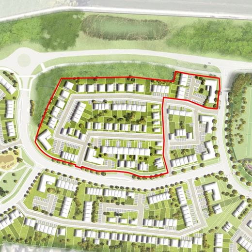
Approximately 6.45 acres (2.61 hectares) with outline planning permission for 116 residential dwellings
KINGSGROVE
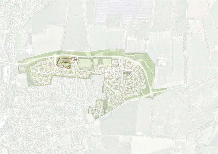
Kingsgrove will become a 227-acre new settlement in the heart of Oxfordshire providing up to 1,534 new homes, a new 2 form entry primary school and neighbourhood centre (including pub/restaurant, retail, care, day nursery, offices and community facilities) on the north eastern edge of Wantage. The landowners and St Modwen Developments have a long-term strategy for the delivery of serviced parcels of residential and commercial development opportunities. Grove Fields is the latest serviced parcel of land to be brought to the open market.
LOCATION
Wantage is a historic market town and the birthplace of King Alfred, marked by his statue located within the town’s large marketplace. Its importance as a market centre over the years has shaped the town with a number of roads converging around its centre, and it has now
grown to accommodate a population of around 13,000 people. The town provides a range of facilities, which also serve a number of surrounding villages. It currently has four primary schools, the Fitzwarren special school, King Alfred’s Community and Sports College, several supermarkets, health and leisure provision, civic buildings and a number of national and independent retailers and restaurants. Proposed growth in Wantage is inextricably linked with the development of Science Value UK. The most recent Employment Land Review estimates between 2012 and 2029 an increase of around 14,300 jobs in the Vale, associated in part with an anticipated 16,000 new jobs identified within the Science Vale UK.
Communications are excellent with the A34(T) linking the M4 and M40 motorways 6 miles away, and Didcot Parkway railway station with regular main line services to London Paddington and Bristol 8 miles away.
THE PROPERTY
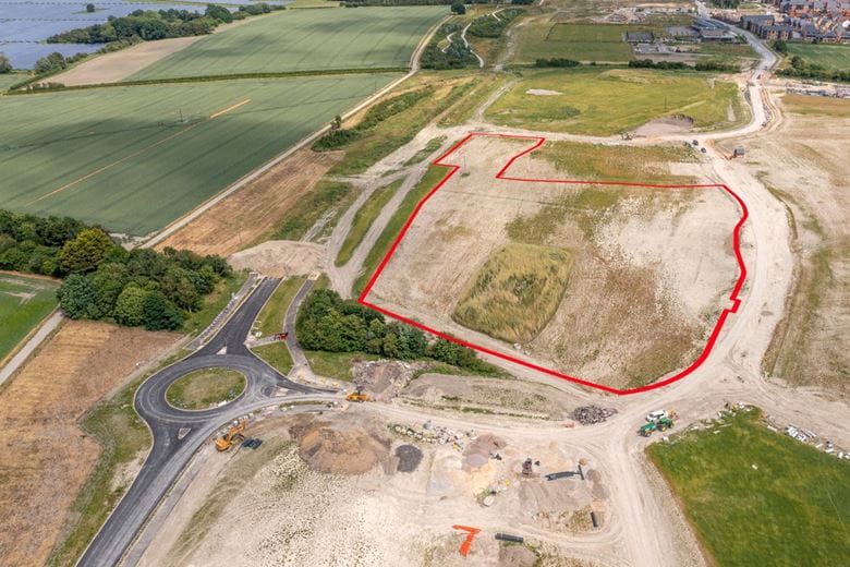
The Property extends to approximately 6.45 acres (2.61 hectares) of former open agricultural land previously in arable use. Grove Fields sits at the heart of the Kingsgrove scheme and land uses immediately neighbouring the parcels will include the following:
• Wantage Eastern Link Road to the north
• Extensive public realm to the east including the Community Garden/Orchard, LEAP, NEAP, MUGA, skateboard park, sports pavilion and three grass sports pitches
• Separate parcels of residential development to the east, south and west
Access to the parcels will be taken from the A417 Reading Road to the south with full vehicular access provided by way of a new access road delivered by the master developer (St Modwen).
PLANNING
Vale of White Horse District Council granted outline planning permission (Reference: P13/V1764/O) for the Kingsgrove Development on 13th July 2015 for:
“Residential development of up to 1,500 dwellings including new employment space (use class B1), a neighbourhood centre/ community hub (use classes A1, A2, A3, A4, A5,B1, C2, D1 and D2), new primary school, central park, ancillary areas (including allotments and sports pitches) with access off the A417 Reading Road. Provision of a strategic link road between the A417 and A338 to be known as the Wantage Eastern Link Road.”
Following detailed work in the preparation of the Site Wide Strategy and the Design Guide to discharge conditions 6, 7, 8, 16 and 17, a number of changes were made to the parameter plans. As a result, a variation of condition application was made to replace the parameter plans
listed at Condition 1. There were also changes to other conditions including Condition 33 (Archaeology) limiting works to two distinct areas of the wider site.
A new Decision Notice was issued, dated 27th November 2017, along with a Deed of Variation to the S106 Agreement. The amendments to the S106 Agreement relate to the timing of some of the secondary school and temporary education payments (P17/V6052/FUL).
The outline permission was further amended to replace the approved parameter plans with new ones that enabled Phase 1B to build slightly higher buildings. The new outline consent was granted by notice dated 28th August 2018 (P19/V1269/FUL). The conditions were reworded to reflect the conditions that have been discharged.
The outline permission was further amended to replace the approved parameter plans with new ones that enabled a rearrangement to the layout of the road through later phases (grove road west and south west). The new outline consent was granted on 14th January 2022 (P21/V2544/FUL). The conditions were reworded reflecting conditions that have been discharged.
The planning permission contains a number of conditions and is subject to a S106 Agreement varied by a Deed of Variation dated 24th November 2017 and further Deed of Variation dated 12th May 2022 and a s278 Agreement (as varied).
The ability to submit reserved matters applications against the extant outline P21/ V2544/FUL expired on 13th July 2023. Therefore, a new outline for the remaining phases of the development was submitted and approved on 2nd November 2023 (P23/ V0134/O). Accordingly, the latest approved Site Wide Strategy is Revision 13.
A S106 and Planning Conditions tracker, setting out obligations between the purchaser and master developer, is provided in the data room.
Therefore, a new outline for the remaining phases of the development was submitted and approved on 2nd November 2023 (P23/ V0134/O). Accordingly, the latest approved Site Wide Strategy is Revision 13.
A S106 and Planning Conditions tracker, setting out obligations between the purchaser and master developer, is provided in the data room.
DISCHARGE OF CONDITIONS
A further application to vary condition 1 was submitted and approved on 14th January 2022, again to vary the parameter plans. The changes relate to the road network in the western part of the scheme.
Various other conditions associated with the planning permission have now been discharged. A full history of the planning activity, including a Section 106 and Planning Conditions Tracker document, can be found on the online Data Room.
RESERVED MATTERS APPLICATIONS
Advanced Infrastructure Works 1b and 2 (P17/V2674)
Reserved matters were approved on 2nd May 2018 in respect of landscaping, SUDS ponds, access road and ground levelling for the majority of the land east of the BOAT.
Advanced Infrastructure Works 4 (P18/V2787/RM)
Reserved matters were approved on 28th February 2019 in respect of AIW4 for the majority of the remaining road network east of the BOAT, the car park for the pavilion (which will be used as drop off by the Primary School), the public square in front of the Community Centre and the open space associated with the woodland to the southeast of the neighbourhood centre.
Advanced Infrastructure Works 4 (P19/V3181/RM)
Reserved matters were approved on 3rd July 2020 in respect of the erection of a sub-station south of the Community Centre and associated access road, landscaping around WELR roundabout on the A417 and the balancing pond on the western and northern boundary.
Advanced Infrastructure Works 6 Reserved matters were approved on 27th June 2022 in respect of land west of the BOAT for construction of new road carriageways (Grove Road Loop Road and Major Access Road), footways, cycleways; reprofiling of land for development, Sustainable Drainage System (SuDS) swales and associated earthworks, allotments, and hard and soft landscaping throughout the site, particularly within the Country Park (northern area of the site), the allotments (western area of the site) and the park within the Grove Road Loop Road. A complete and up to date suite of planning documents and applications is available on the online Data Room.
THE PROPOSED DEVELOPMENT
The Property is ready to commence development and the following works have been or will be delivered by the master developer (St Modwen) to provide a serviced land parcel:
• New utility connections including gas, electricity, water and telephony communications
• Site clearance and earthworks
• Hard and soft landscaping up to the red line boundary of the Property
• Completion of the major access road
• Foul and surface water connection up to the red line boundary of the Property.
The purchaser will be responsible for all remaining works required (as set out in the technical buyer/seller works pack), together with various planning conditions as set out on the online Data Room.
FURTHER INFORMATION
A Data Room has been prepared to accompany these particulars and includes all relevant planning, technical, legal and legal information, as well as bidding guidance.
Prospective purchasers should note that the Vendors will expect them to have obtained and carefully considered the contents of the Data Room prior to submitting their offer.
www.kingsgrove-wantage.info
VAT
VAT will be charged on the sale price.
METHOD OF SALE
The opportunity is offered for sale freehold with vacant possession by informal tender with unconditional offers sought. The Vendors may consider the provision of overage as a part of offers received. Please note that the purchaser will be permitted to build up to 116 dwellings only.
Offers should be received by email in accordance with the Bidding Guidance contained on the Data Room and received by 12 noon on Thursday 16th May 2024, marked “Grove Fields (Phase 7) Kingsgrove Tender”.
VIEWING
The property may be viewed from the highway. Parties wishing to walk the site should arrange an appointment with Carter Jonas.

Suggested properties
Here are a few properties you might like, but within 2 extra miles of your current search


